
Paracas map: town, arrivals and boat departure orientation
Separate your Paracas road arrival, El Chaco office, boat pier and mainland reserve route with this original orientation diagram.
.jpg)
BallestasIslands.com is an independent travel guide. We are not SERNANP, a reserve authority or a tour operator.
Start with the exact arrival point on your ticket. Find the room or supplier office next, then follow the branch you booked: the confirmed pier for a boat, or Santo Domingo access for a reserve land visit. Save the return point too. The map is an orientation aid with separate choices, not a promise that all services share one compact meeting place.
On this page14
- Read the Paracas map
- Numbered marker reference
- Arrival points and the last mile
- El Chaco and the departure area
- Town landmarks and services
- The reserve is another branch
- Walking boundaries and map shortcuts
- Connections to the island map
- Sources, scale and corrections
- Put the map to work before arrival
- Make a small offline arrival card
- Check one final detail before setting out
- Continue with the related guide
- Verdict on using a Paracas map
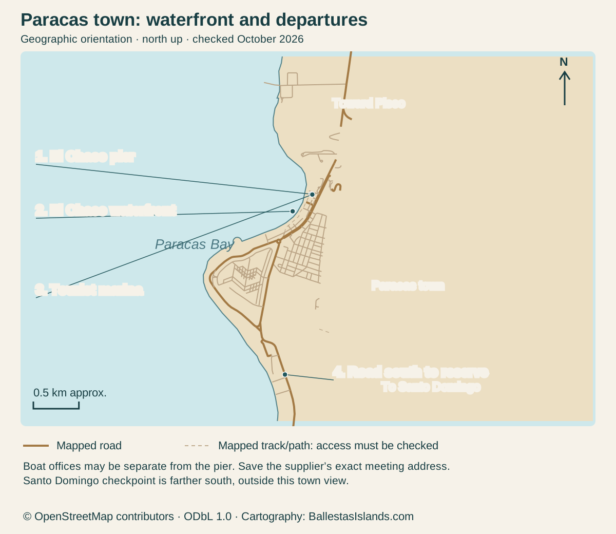
Use this Paracas map reference to keep your road arrival, El Chaco waterfront, boat departure and mainland reserve separate. A town pin is not an office address, and a boat pier is not the reserve entrance. The map shows the coastline, El Chaco, mapped roads and departure-area features in their geographic positions.
Your town and departure markers
Enlarge the map, then scroll to explore
North is up. Numbered markers in the map match the complete place records below. Mapped roads and paths do not establish current access permission.
Details for each option
Marker: 1
- Place / reference
- El Chaco pier
- Use and limitation
- Confirm the supplier’s office and boarding point
Marker: 2
- Place / reference
- El Chaco waterfront
- Use and limitation
- Locate the actual room or meal venue
Marker: 3
- Place / reference
- Tourist marina
- Use and limitation
- A mapped departure-area feature; confirm the booked pier
Marker: 4
- Place / reference
- Road south to reserve
- Use and limitation
- Santo Domingo checkpoint lies farther south, outside this town view
OpenStreetMap geometry; official visitor sources below · · © OpenStreetMap contributors, ODbL 1.0. Original cartography by BallestasIslands.com.
Read the Paracas map
Open the map at full size (tap to enlarge).
The pier and marina labels mark the departure area; the road south leads toward the reserve, whose checkpoint is outside this town view. You can book a boat, a land visit or both with a clear connection. The map does not imply that a single ticket covers them.
PROMPERÚ's visitor page names the departure context. SERNANP's circuit map names the mainland access and stops. Checked October 2026. Neither source gives the check-in desk for every commercial booking.
Numbered marker reference
The markers use OpenStreetMap geometry. They are orientation features, not a claim that every booking starts at one of those exact pins. Your road arrival depends on the transport service, and your boat office depends on the supplier. Obtain those exact pins from the people holding the booking.
Keep the entrance address in plain text as well as a map pin. A dropped pin can be shared without its original explanation. The written name helps you and a driver check that it is the correct entrance.
Arrival points and the last mile
Start with the terminal named on the ticket, not a search for “Paracas bus station” after arrival. Different services can use different places. A broad destination label does not prove a waterfront drop-off.
If your service ends in Pisco, plan the next road leg. Do not treat the city name as a harmless spelling variant. Ask how you reach the exact Paracas address and what that adds to the day.
For a pre-arranged car, agree the meeting method. Save the driver or operating firm's contact and explain a bus delay through the agreed channel. A person waiting nearby with a similar first name is not enough to identify the service.
For Lima travel, include reaching the departure terminal before the intercity leg. For Ica, check the direction and final local connection separately. The town map cannot replace a dated service offer.
El Chaco and the departure area
El Chaco is the waterfront setting used for visitor services and many boat arrangements. It is useful orientation, but it is not a universal meeting point. Ask where the seller checks passengers in and where the group boards.
PROMPERÚ also names the Paracas Tourist Marina as a departure point. That does not mean your booking uses it. Use the supplier's current instruction for the actual sailing.
An office and pier can be distinct places. Allow time to register, deal with any separately paid charge and walk with the group to board. Do not use the advertised sailing time as your first arrival at the waterfront.
For a return pickup, ask which pier the boat expects to use. The driver needs a usable meeting address. “Where we left” can fail if the service finishes elsewhere or road access changes.
Town landmarks and services
Use fixed addresses to organise practical needs. Your accommodation entrance, the boat office and a chosen meal venue are better anchors than a broad beach label. Save each one with its purpose.
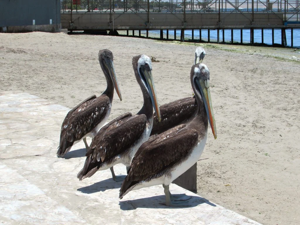
The hero photograph shows pelicans near the Paracas waterfront and pier setting. It is a real photographed scene, not a current guide to pier access. Do not use wildlife in an old image as a navigational marker.
For luggage, ask where it can wait before check-in or after checkout. A map can show a property while telling you nothing about its storage terms. Get that answer before leaving a large bag during an outing.
For toilets, food and cash, use current local information. Do not assume every marked business is open early enough for a boat morning. An address is only one part of a service you can actually use.
The reserve is another branch
The mainland reserve has its own access and permitted circuit. Reaching the town or pier does not provide transport between the coastal stops. Arrange that land service deliberately.
The reserve map gives the named visitor places and the limits of a map. It does not grant vehicle access. Follow the current instruction from reserve staff.
If a package includes both branches, ask where and when the land vehicle meets the boat group. Include bags and a possible late return. A line joining two boxes on a map would not create a workable connection by itself.
Choose the local excursion comparison if you are still deciding which branch you want. A broad “Paracas tour” title needs to state the actual boat or land content before you can compare it fairly.
Walking boundaries and map shortcuts
Do not assume every route drawn by a phone app is a permitted walk. Shore edges, private property, piers and roads can have limits. Use public access and follow current signs.
For anyone with a mobility need, ask about the actual surface and steps. A short distance can still contain a difficult section. Describe what the person needs rather than relying on a general “close to the port” claim.
If you have bags, check where the car can stop. An entrance that is easy for a pedestrian may be awkward for a vehicle pickup. Save the agreed side of the property so the driver and group do not search for each other.
Avoid crossing an active road while reading directions. Pause somewhere suitable and agree the next step before moving. A few clear addresses make this easier than following several uncertain pins at once.
Connections to the island map
The island map reference begins with the departure coast and explains the offshore stage. It is distinct from the town-arrival task shown here. Neither map is a marine chart.
The Candelabra feature is on the coastal slope, while Ballestas is offshore. Seeing both from the boat does not turn the outing into a reserve land circuit. Keep that distinction when reading a package's list of places.
For animal expectations, use the appropriate wildlife guide rather than a map symbol. A bird or sea-lion icon on tourism material indicates an interest, not a guaranteed sighting at that point. Animals move and viewing angles change.
Map data: © OpenStreetMap contributors, ODbL 1.0. Download the source data. Cartography by BallestasIslands.com. Checked October 2026. The source data includes mapped features beyond the visible frame.
Sources, scale and corrections
This map is original cartography drawn from OpenStreetMap coastline and road geometry. North is up and the scale bar gives approximate ground distance. It does not copy commercial tiles or draw a protected-area boundary. The mapped marina and pier are close together, so enlarge the map to separate their labels.
The numbered table repeats its meaning. Open the SVG for a larger view on a phone or print it as a short planning reference. Nothing depends on a hover state or JavaScript loading.
Use the provider's latest message when a meeting point changes. A static reference should not be used to challenge a current valid instruction. If two messages conflict, ask the booked provider to settle the exact place before travelling.
Report a factual error through the contact page with the source and the place concerned. A change to an individual commercial office may not change the broader map, but it does change your booking plan. Keep both levels clear.
Put the map to work before arrival
Make a short note with the arrival terminal, room entrance and first outing's office. Add the pier or reserve pickup once confirmed. Then include the onward departure and the route to it.
For a group, share that note so one phone is not the only copy. Ask each person to recognise the same meeting place. This is particularly useful when some members skip an activity or arrive separately.
Leave room between fixed stages. A map makes places look static, while the visit includes queues, bags and road time. Use real service details to turn orientation into a realistic day.
Make a small offline arrival card
Save three addresses before travel: where you arrive, where your bags will be and where the next booked activity starts. Write the purpose beside each. A phone full of pins is less useful if you cannot tell the tour office from the hotel entrance after a long journey.
Add the contact from each booking. Use the number or message route on the voucher, not the first result found after arrival. If a driver meets you, save how you will identify the service. A person calling your destination may be offering a different ride.
Keep a plain-text copy as well as a map screenshot. A pin can lose its label when shared, and a screenshot may crop out the street name. The written address gives you another way to check the place with staff or a driver.
For the return, add the exact terminal printed on your onward ticket. Ask how you will get there from the outing's actual finish. Do not assume the tour ends where it started or that every bus company uses one station.
Use landmarks as context, then check the entrance
A known hotel or plaza can help explain a meeting point. It does not replace the office door or the instructions on the voucher. Ask which side of the building to use and whether the office is set back from the waterfront.
If the pin and written address disagree, ask the provider before setting out. Do not choose one at random. Send the two details through the confirmed contact route and request a single clear meeting instruction.
For a group, share the final address with everyone. Agree where to wait if someone is delayed. This reduces the chance that one person goes to the pier while another waits at the office. It also leaves more of the arrival for the visit itself.
Check one final detail before setting out
Read the saved address aloud with the person arranging the ride. Confirm its purpose: the room entrance, the tour office or the terminal. This small check can catch a wrong pin before the journey starts, when it is still easy to correct.
Continue with the related guide
Verdict on using a Paracas map
Use the Paracas map to separate road arrival, waterfront services and the two main outing branches. Then obtain exact booking addresses and return points. That is more useful than treating a single town pin as the answer to every check-in, transfer and reserve-access question.