
Huacachina map: lagoon, streets and dune access
Use a simple Huacachina locator and marker reference to separate Ica arrivals, the lagoon and dune access questions.

BallestasIslands.com is an independent travel guide. We are not SERNANP, a reserve authority or a tour operator.
Arrive at the terminal printed on your ticket, arrange the road connection to a named Huacachina address, then check the permitted access for any dune visit. Save the property entrance and outing meeting point separately. The lagoon is a useful landmark. A pin in its centre is not a practical pickup address.
On this page8
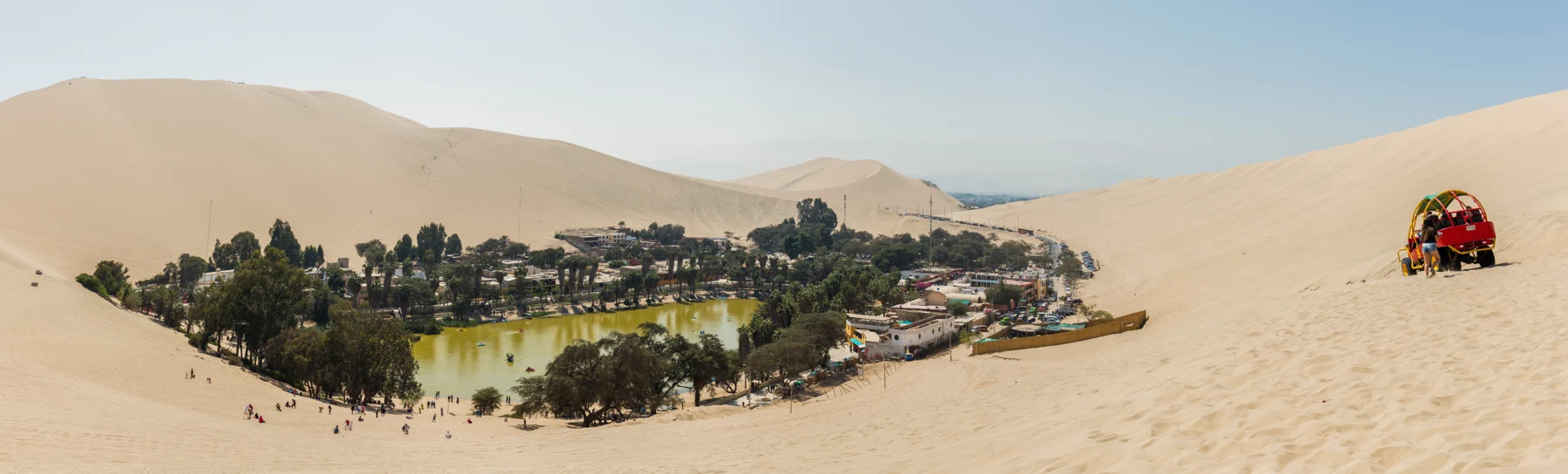
Use this Huacachina map to distinguish three places: Ica, the lagoon village and the dunes around it. Your bus terminal is an arrival point in Ica, not a dune-tour meeting point. The map shows the lagoon outline, road approach and village in their geographic positions. Dashed mapped paths are not proof of permitted dune access.
Lagoon, road and village markers
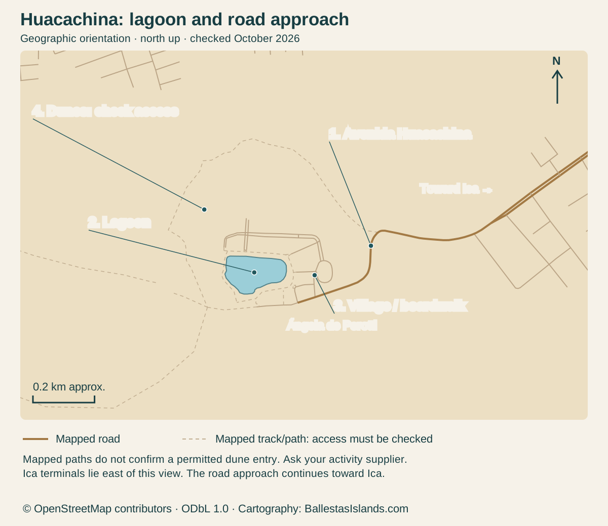
Enlarge the map, then scroll to explore
North is up. Numbered markers in the map match the complete place records below. Mapped roads and paths do not establish current access permission.
Details for each option
Marker: 1
- Place / reference
- Avenida Huacachina
- Use and limitation
- Mapped road approach from the Ica side
Marker: 2
- Place / reference
- Lagoon
- Use and limitation
- Water outline is a landmark, not a bathing permission
Marker: 3
- Place / reference
- Village / boardwalk
- Use and limitation
- Confirm your property entrance or activity office
Marker: 4
- Place / reference
- Dune setting
- Use and limitation
- No confirmed public entry gate is established here; ask your supplier
OpenStreetMap geometry; official visitor sources below · · © OpenStreetMap contributors, ODbL 1.0. Original cartography by BallestasIslands.com.
Read the Huacachina map
Open the map at full size (tap to enlarge).
North is up, and the scale bar gives approximate ground distance. The solid road reaches the settlement from the Ica side. Dashed lines are paths or tracks recorded in OpenStreetMap. They do not establish a permitted entry into the dunes. Ask the responsible supplier where your outing starts.
For the setting, NASA's landscape account places the lagoon beside Ica and among dunes. For road orientation, PROMPERÚ's visitor page explains the Ica connection. Neither is a live map of today's barriers or vehicle movements.
Lagoon and village markers
Checked October 2026. Markers locate the road approach, lagoon, village and surrounding dunes. Ica’s intercity terminals are beyond this view to the east. Marker 4 identifies the dune setting, not a confirmed entry gate. Ask your supplier for the actual permitted meeting point.
The lagoon helps you recognise the village. It is not an instruction to walk into the water or cut through planted edges. Use public access and respect signs around the shore.
Arrive from the actual Ica terminal
Find the terminal before you choose a transfer. An intercity company's Ica stop may differ from another firm's stop. If someone is meeting you, send the company name and arrival details, then agree how you will identify the driver.
Save a screenshot of the property entrance. A driver may recognise the business. A map pin gives you a way to check the place too. Do not leave the final address as “the oasis” if you have bags, a mobility need or a fixed check-in.
The Ica connection guide covers fares and pickup questions. A taxi quote should name the whole journey and group. Ask whether any waiting or extra stop changes the amount.
Dune access points need current confirmation
No dune entrance is marked here as universally open. Access and route use must come from the manager or a current local instruction. Vehicle tracks are not proof that pedestrians should follow them.
The regional wind-closure notice from September 2025 is a useful example of access changing with conditions. It does not state the position for your travel date. Ask what is open now and who has issued that instruction.
If a guided trip includes a transfer into the dunes, ask where you meet and where you return. A pickup at a hotel and a finish at an office are not interchangeable when your bags are elsewhere. Keep those details in the same place as the booking.
Walking and transport boundaries
Do not read a short line on a phone map as a simple walk. Loose sand, a steep slope or a vehicle area can change the job. A map app may not know the local access rule.
Agree a known route back before climbing. Choose a turn-round point that leaves enough light and energy for the descent. When a route is unclear, a shorter visit is a useful choice, not a failed visit.
For a late finish, arrange the final road connection while staff and transport are easy to contact. Ask for the pickup side of the village and a recognisable meeting point. A centre-of-lagoon pin is poor guidance for a car.
Map data: © OpenStreetMap contributors, ODbL 1.0. Download the source data. Cartography by BallestasIslands.com. Checked October 2026. The source data includes mapped features beyond the visible frame.
Sources and map corrections
This original map uses OpenStreetMap road, water and path geometry. No commercial map tiles are copied. It has a north arrow and approximate scale.
It can be printed and read without JavaScript. Open the SVG for a larger view on a phone. Its numbered text repeats in the marker table so the meaning does not depend on colour.
If your supplier changes its meeting point, update your booking details rather than assuming this reference has endorsed the old one. Send any factual correction through the contact page with the exact place and source. Do not use this map for vehicle navigation.
Continue with the related guide
Verdict on using a Huacachina map
Use this Huacachina map to plan the visit you want. Use the map to keep the road arrival, lagoon and dunes distinct. Then get exact addresses for the parts you book. Return to the Huacachina guide for visit choices, and compare local tours only after you know where the outing starts and ends.