
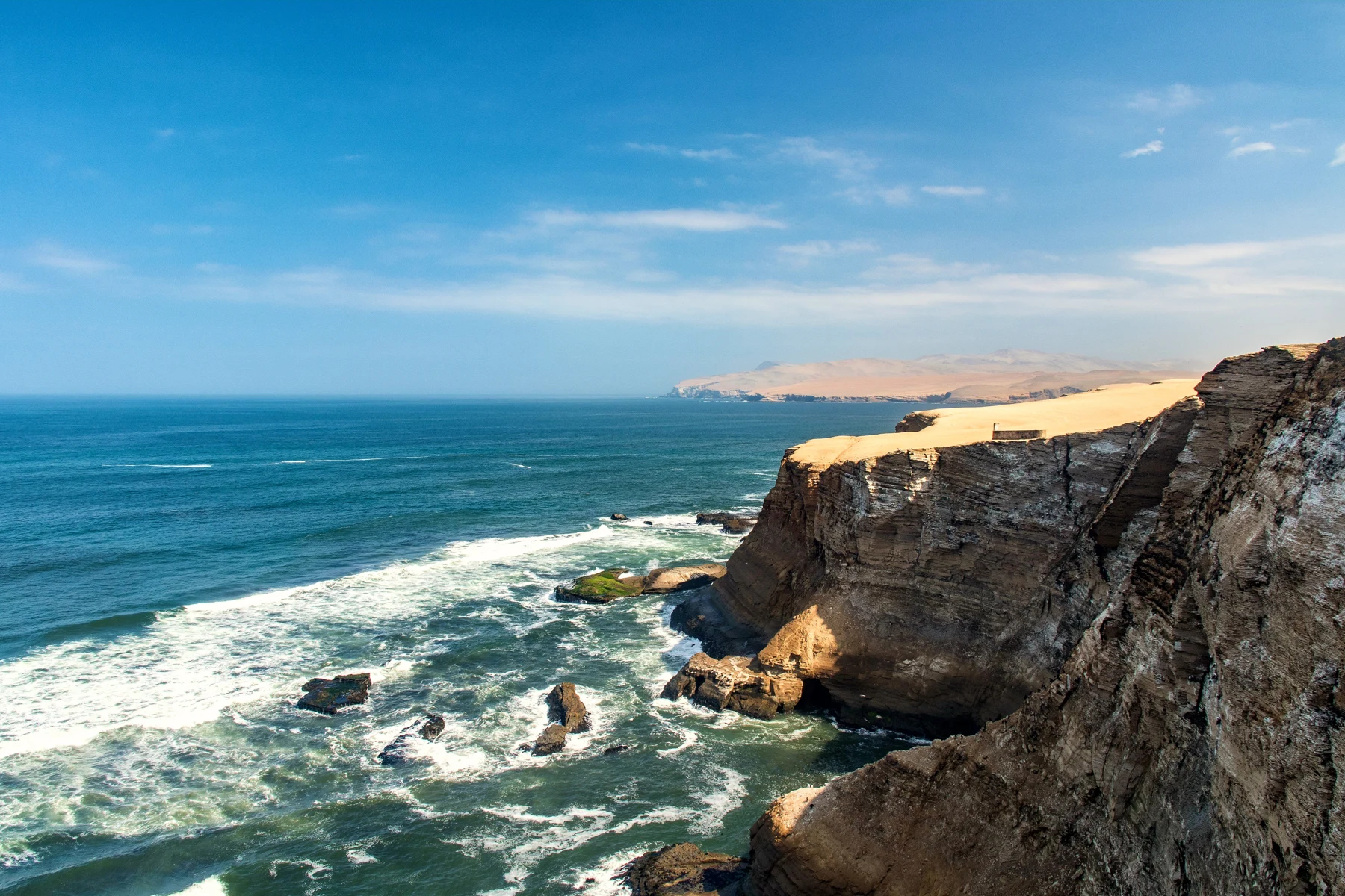
Paracas national reserve map: routes, beaches and viewpoints
Use Santo Domingo as the official distance reference and distinguish reserve viewpoints, beach stops and the site museum.

BallestasIslands.com is an independent travel guide. We are not SERNANP, a reserve authority or a tour operator.
Start by confirming entry at Santo Domingo, then choose the permitted stops that fit the visit you want. Keep a viewpoint, a beach stay and the site museum distinct. The official map's distances use the checkpoint as their reference, not your hotel or the last stop. Arrange transport for the whole route and check the return before entering.
On this page12
- Read the Paracas National Reserve map
- Entrance and permitted routes
- Marker and distance reference
- Beaches, museum and viewpoints do different jobs
- Access restrictions by stop
- Transport and distance limitations
- Read service symbols with care
- Fit the map to your day
- Sources and corrections
- Read the official distance list without adding the rows
- Continue with the related guide
- Verdict on the Paracas National Reserve map
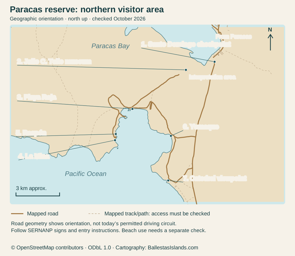
This Paracas National Reserve map reference groups the visitor entrance, interpretation and museum area, coastal viewpoints and beach choices. Use the official circuit for road orientation and current staff instructions for permission. The geographic map below draws the coastline and mapped roads with named visitor places. It is a planning aid, not a claim that every road or stop is currently open.
Official northern circuit distances
Enlarge the map, then scroll to explore
North is up. Numbered markers in the map match the complete place records below. Mapped roads and paths do not establish current access permission.
Details for each option
Marker / place: 1. Santo Domingo checkpoint
- Official distance from Santo Domingo
- Distance origin
- Use and limitation
- Entry and current circuit instruction
Marker / place: 2. Julio C. Tello museum
- Official distance from Santo Domingo
- Separate facility
- Use and limitation
- Check its own entry and opening
Marker / place: 3. Playa Roja
- Official distance from Santo Domingo
- 7 km
- Use and limitation
- Viewpoint; follow shore-access restrictions
Marker / place: 4. La Mina
- Official distance from Santo Domingo
- 12 km
- Use and limitation
- Check beach use and current conditions
Marker / place: 5. Raspón
- Official distance from Santo Domingo
- 12 km
- Use and limitation
- Check approach and current use
Marker / place: 6. Yumaque
- Official distance from Santo Domingo
- 8 km
- Use and limitation
- Named coastal stop; check current access
Marker / place: 7. Catedral viewpoint
- Official distance from Santo Domingo
- 10 km
- Use and limitation
- Follow the permitted viewpoint approach
OpenStreetMap geometry; official visitor sources below · · © OpenStreetMap contributors, ODbL 1.0. Original cartography by BallestasIslands.com.
Read the Paracas National Reserve map
Open the map at full size (tap to enlarge).
For the actual official road illustration, use SERNANP's published circuit PDF. Checked October 2026. This page does not copy its map artwork. The original map below uses OpenStreetMap geometry for coastline and roads. The SERNANP PDF supplies the official circuit context and the checkpoint-based distance list.
Solid lines are mapped roads; dashed lines are mapped tracks or paths. Their presence is not permission to drive them. The current permitted route may depend on the vehicle and conditions. Ask at the entrance and follow signs on the ground.
Entrance and permitted routes
The official visitor information names the Santo Domingo checkpoint for access. Use that as the reference when reading its distance list. A hotel-to-beach journey includes whatever road approach comes before the checkpoint too.
Ask whether your vehicle and intended circuit are allowed. A rental agreement does not prove reserve permission. Do not assume that an access rule for bicycles, cars or another vehicle also covers a scooter.
The reserve visitor page is the official starting source. Checked October 2026. A map from a previous season cannot override today's staff instruction or a barrier.
For a guided outing, ask the operator to name the stops and vehicle. “Full reserve” is too broad to compare fairly. A clear list also shows whether the museum or a longer beach stay is actually included.
Marker and distance reference
Distances above are those printed in SERNANP's circuit PDF, checked October 2026. They are not measured here and are not the distances between each pair of rows. Do not add them together as if they form one sequential route.
Use them to understand scale, then ask the provider how its actual circuit runs. Stops and walking time are additional to the road distance. A route can be short on a map while still requiring much of a visit.
Beaches, museum and viewpoints do different jobs
The interpretation centre introduces the reserve's natural setting. The Julio C. Tello site museum is a separate facility under the Ministry of Culture. Do not treat the two names as interchangeable when booking a driver or checking opening.
At a viewpoint, the task is to reach a permitted viewing position and return to the vehicle. A beach stay needs more detail about access, facilities and water use. The same amount of time will not serve both purposes.
Playa Roja is a viewing choice in this guide. La Mina needs its own beach-use check. Nearby Raspón and other beaches should be compared by the actual approach and current instructions.
The museum also has its own schedule and admission. Passing the area during a circuit is not a visit inside. Ask whether the itinerary leaves enough time and whether the entry is included.
Access restrictions by stop
A place marked on the map is not automatically open for every use. Current route, beach and facility instructions may differ. Ask about the exact activity: viewing, walking, bathing or another use.
For Playa Roja, follow the permitted viewpoint and barriers. Do not assume a way onto the red shore. A photograph from sand level does not show that the same approach is legal or suitable now.
For beaches marked for bathing on the official map, obtain current local advice. The symbol is not a daily sea-state or water-quality clearance. It does not prove that lifeguards or every service are present during your visit.
For a closed or unclear route, choose another permitted stop. Do not use the map to invent a bypass. Protected-area rules apply to the ground between attractions as well as the named places.
Transport and distance limitations
Arrange movement for the whole route, including the return. A car dropping you at the checkpoint is not transport between beaches. A one-way taxi quote also does not promise a later pickup from a remote stop.
Ask how long the group spends outside the vehicle. A circuit's total duration can include entry, road time and waiting. If you want patient birdwatching or a longer beach stay, state that before buying a general sightseeing route.
For a private vehicle, check whether the intended roads and stops fit the rental and insurance terms. Keep the vehicle on permitted routes. A bare-looking desert is not an invitation to drive a shortcut.
The scooter guide separates those questions. The land-tour comparison is useful when you prefer an organised vehicle. Both still require current route confirmation.
Read service symbols with care
The official map includes symbols for toilets, snacks and other visitor interests. They can help you decide what to ask. They do not establish opening hours, stock or staffing for your date.
If a facility matters to the group, confirm it before leaving town. Carry water and essentials rather than relying on an unconfirmed shop. A longer beach plan may need a different level of preparation from a short viewpoint pause.
For access needs, ask about steps and surfaces at the exact stop. A service symbol or a small distance figure cannot show the whole approach. A clear description from the provider is more useful than a broad “suitable for everyone” statement.
For wildlife, treat map icons as interests, not promised sightings. A bird can be recorded in a habitat without being visible during your stop. Give observation time to the setting rather than demanding a result from an icon.
Fit the map to your day
Choose the main purpose first. For coastal scenery, select a sensible circuit with time to look. For a beach stay, protect the time at that beach. For the museum, make its opening and entry the fixed point around which the land journey fits.
If the day begins with a boat, include the transfer from the return pier to the land vehicle. A sailing delay can shorten the reserve visit. Ask what changes in that case before buying a combined package.
For an onward bus, work backwards from terminal check-in. Include driving out of the reserve and collecting bags. A viewpoint's closing time is not the time you can safely begin a long chain of connections.
The town map handles the arrival side. Keep it beside this reference so the journey from your room or terminal is not lost between two different maps.
Map data: © OpenStreetMap contributors, ODbL 1.0. Download the source data. Cartography by BallestasIslands.com. Checked October 2026. The source data includes mapped features beyond the visible frame.
Sources and corrections
The original map uses OpenStreetMap coastline and road geometry. The visitor places and distance table are checked against the official circuit reference. It is north-up, with an approximate scale bar. It does not reproduce a legal boundary or replace current entry instructions.
The text table repeats the image's purpose and gives the distance origin. Open the SVG for a larger view or print it with the table. The reference remains usable without JavaScript and without relying on colour alone.
If an operator's current route differs from an old map, ask why and check the official instruction. A valid restriction can change a commercial itinerary. Do not assume either source is current simply because its image looks more polished.
Report a factual correction through the contact page with the exact source. Current meeting points belong to your booking provider, while reserve access belongs to the responsible authority. Keep those responsibilities distinct when resolving conflicting directions.
Read the official distance list without adding the rows
The official circuit uses Santo Domingo as its distance reference. Playa Roja is shown at 7 kilometres, Yumaque at 8, Catedral at 10, and La Mina and Raspón at 12. These figures do not describe a single chain of legs. Each starts from the checkpoint reference used by the map.
For example, the two 12-kilometre entries do not mean you drive 12 kilometres from one beach to the other. Nor does adding all the figures give a circuit total. Ask a driver for the route it will use and the actual road legs between the chosen stops.
The journey from your room or bus terminal comes before that reference. Add it when you plan the day. Entry checks, walking and time at each stop come on top of the driving. A distance list alone cannot tell you when you will return to town.
Turn the symbols into questions
The northern map gives bathing symbols to La Mina, Raspón and Yumaque. It shows Playa Roja as a viewpoint. Use that difference to choose the type of stop you want. Then ask staff about current use and conditions rather than treating the printed symbol as a guarantee for today.
The same care applies to toilet and food symbols. They help you ask where to plan a break. They do not confirm that each service is open or has what your group needs. Ask before leaving town if a facility is essential to the visit.
For the museum, keep two names apart. The interpretation centre explains the natural place; Julio C. Tello is the site museum for the cultural visit. Give the driver the full name and check its own opening. A generic “museum” marker can leave this task unresolved.
Choose a route you can change sensibly
Mark the one stop that matters most to you. Then identify a lower-priority stop to drop if entry or the road takes longer than planned. This gives the driver a clear basis for a change instead of shortening every stop equally.
Agree on a fallback when the main stop is closed. You might prefer another view, a museum visit if open, or an earlier return. Check whether a change affects the price or the finish. A route map helps you discuss choices, but the actual booking must state what happens when the day changes.
Keep the final return point in the plan. A trip ending at the reserve entrance differs from one ending at your hotel or terminal. Leave time for the extra leg if the quoted service does not cover it. That is how the map becomes part of a usable day rather than just a list of places.
Continue with the related guide
Verdict on the Paracas National Reserve map
Use the Paracas National Reserve map to choose the right stops and understand the checkpoint-based distances. Then confirm the actual route, transport and current access. The reference is strongest when it helps you ask precise questions, with a clear return plan and no assumption that every mapped place is open for every activity.