
Ballestas Islands map
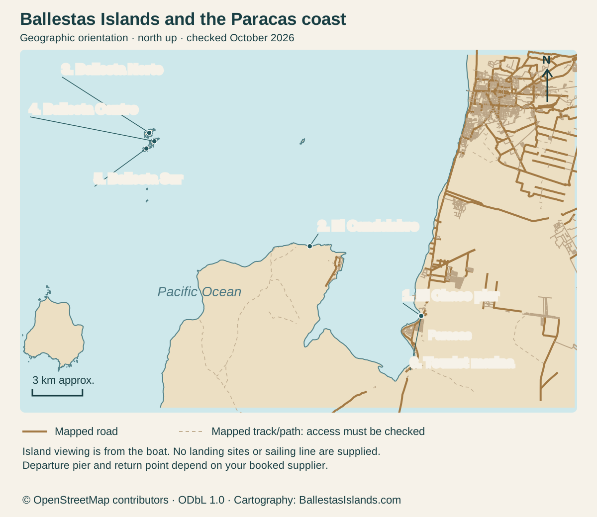
Find the departure coast and offshore islands. An orientation map, not a sailing chart.
Markers on the island route
Locate the departure coast and offshore islands. This orientation map is not a sailing chart or permission to land.
Enlarge the map, then scroll to explore
Details for each option
| Marker | Place / reference | Use and limitation |
|---|---|---|
| 1 | El Chaco pier | Mapped departure-area feature; confirm your office and boarding pier |
| 2 | El Candelabro | Mainland coastal mark; the boat route and view can change |
| 3 | Ballesta Norte | Offshore island group; viewing from the boat |
| 4 | Ballesta Centro | Offshore island group; no public landing plan |
| 5 | Ballesta Sur | Offshore island group; follow the crew’s instructions |
| 6 | Tourist marina | Mapped near the El Chaco departure area; confirm actual use |
North is up. Numbered map markers match the complete place records. Mapped roads and paths do not establish current access permission.
OpenStreetMap geometry; MINCETUR and PROMPERU place context · · © OpenStreetMap contributors, ODbL 1.0. Original cartography by BallestasIslands.com.
How to use this reference
BallestasIslands.com is an independent travel guide. We are not SERNANP, a reserve authority or a tour operator.
Start at the confirmed Paracas pier, keep the mainland Candelabra mark distinct from the offshore islands, and plan to view the rocks from the boat. Ballestas belongs to the RNSIIPG reserve system. The mainland Paracas National Reserve is a separate visit. The map shows the places. The crew follows the route allowed for the conditions.
This Ballestas Islands map shows where the boat starts on the Paracas coast. It also marks El Candelabro and the island groups offshore. It shows places on a usual visitor route. It is not a marine chart. Use it to picture the outing. Get the meeting point and sailing details from your boat supplier.
Read the Ballestas Islands map
Open the map at full size (tap to enlarge).
North is up. The shoreline and the three named island groups show their real relative positions. The scale bar gives approximate ground distance, not a sailing distance.
The crew chooses the permitted route for the conditions. Do not use the image to navigate a vessel or judge how close it may approach a rock. Ask the crew about the route for your departure.
The MINCETUR inventory record describes the Paracas pier, Candelabra and island stages. It also describes three island groups. Checked October 2026. The record has old journey times and fares. Use a current supplier quote for those details.
Departure area and island groups
Paracas is the mainland starting context. Your actual check-in may be at an office or a point beside a pier. Ask for both the address and the pier name. Do not assume the first boat desk you see is the one holding your booking.
PROMPERÚ's visitor page names El Chaco Pier and the Paracas Tourist Marina as departure points. Checked October 2026. That source does not prove every departure uses both or that a particular pier is active on your date.
Ballestas is offshore. The islands and their surrounding water belong to a protected coastal system. A dot on a tourism map does not mean a public landing place. Keep the rocks as the wildlife setting you see from the vessel.
The marina and El Chaco pier are mapped departure-area features, not a claim that every vessel uses the same point. Save the actual answer with the meeting details. This prevents a map's broad place name from deciding a specific transfer.
El Candelabro and route orientation
El Candelabro is the large mark on the coastal slope, distinct from the island rocks. On a typical described visitor route, it is a feature seen from the water before the island stage. That sequence helps you understand why a boat trip can include a mainland feature without becoming a land tour.
Do not turn the route description into a visibility promise. Light, sea conditions and operating decisions can affect the view. Ask the supplier what its actual itinerary includes and what happens when the route changes.
This map does not claim an origin date or purpose for the mark. Those are separate historical questions. For planning the boat, the useful fact is its coastal location and its place in the described route.
If photographs are important to you, ask how views are managed for both sides of the boat. Do not demand a closer or longer approach against the crew's instructions. A map explains places; it does not grant a right to a particular photograph.
Boat viewing and landing limits
Plan the island visit from the water. Do not make a walking itinerary for the island groups or assume a beach-like area is a public stop. A place can be visible and still be unsuitable or restricted for landing.
Follow the crew's instructions about seating and movement. Keep bags and loose items secure. When wildlife is close enough to observe, use that view without asking for a disturbance that makes animals move.
For the protected-area context, SERNANP's reserve-system account explains the wider chain of islands and guano points. Its full extent is much larger than this visitor map. Do not read the map as the legal boundary of the whole reserve.
No depth, tide, hazard or safe-distance information is supplied in this image. It cannot replace current maritime instructions. A boat crew needs the right official charts and current sailing rules.
Mainland reserve versus offshore islands
The Paracas National Reserve is a separate land and marine protected-area visit with its own visitor routes. The common place name can cause confusion when tickets and tours use “Paracas” loosely.
Ask which place a quoted entry covers. A boat fare, an island entry, a pier charge and a mainland reserve ticket are different items. If a seller bundles them, request an itemised explanation rather than using one price from a map or blog.
The distinction affects time too. A boat morning does not automatically leave room for a complete mainland circuit and an inland transfer. Choose the parts you want and ask for the actual return point before adding another fixed booking.
The Ballestas overview gives the place answer. The boat trip comparison handles departure formats and the questions to ask before paying. Use this map alongside those decisions rather than as a booking checklist on its own.
Map data: © OpenStreetMap contributors, ODbL 1.0. Download the source data. Cartography by BallestasIslands.com. Checked October 2026. The source data includes mapped features beyond the visible frame.
Sources, scale and corrections
The map is original cartography drawn from OpenStreetMap coastline and road data, checked October 2026. It shows Ballesta Norte, Centro and Sur west of the departure coast. Official visitor sources above confirm the place names and outing context. No protected-area boundary or sailing route is drawn.
It can be opened as an SVG, enlarged on a phone and printed. The marker table repeats its meaning in text. The text explains how the places relate. You do not need colour, a mouse or scripts to use it.
If a supplier changes a pier, use the current booking message for that departure. An old route illustration is not evidence against a new official instruction. Report a factual place error through the contact page with the exact source so it can be checked.
Continue with the related guide
Verdict on using a Ballestas Islands map
Use the Ballestas Islands map to keep the departure coast, Candelabra and offshore rocks distinct. Then confirm the real pier, charges and return arrangement. Use the map to picture the trip. It is not a chart, a landing permit or a fixed sailing route.